- About Us
- Board of Directors
- Sections
- Guiding Documents
- Join APA and Its Divisions
- Contact Us
- Washington Planning Awards Information
- Events & Training
- Professional Development
- Sponsorship
- Get Involved
- Resources
|
Next City: Fifth and Sixth Grade Students Learn How to Plan a City as part of the University of Washington’s Summer Challenge Program
By Stephanie Velasco Have you ever wondered how cities get built? Who decides where houses, parks, shops, and schools go and what they look like? Who makes sure people are able to get around the city safely and easily? In Next City, students took on the roles of urban planners, architects, and landscape architects, as they answered these questions, played city-related games, and honed their drawing, modeling, and group discussion skills. Weekly field trips took students out into Seattle to observe the city up close. Finally, students drew inspiration from cities around the world as they planned, designed, and built their very own Next City from scratch. Each week focused on specific learning and skill building goals with classroom activities and a field trips to match, as outlined below: Week One
Week Two
Week Three
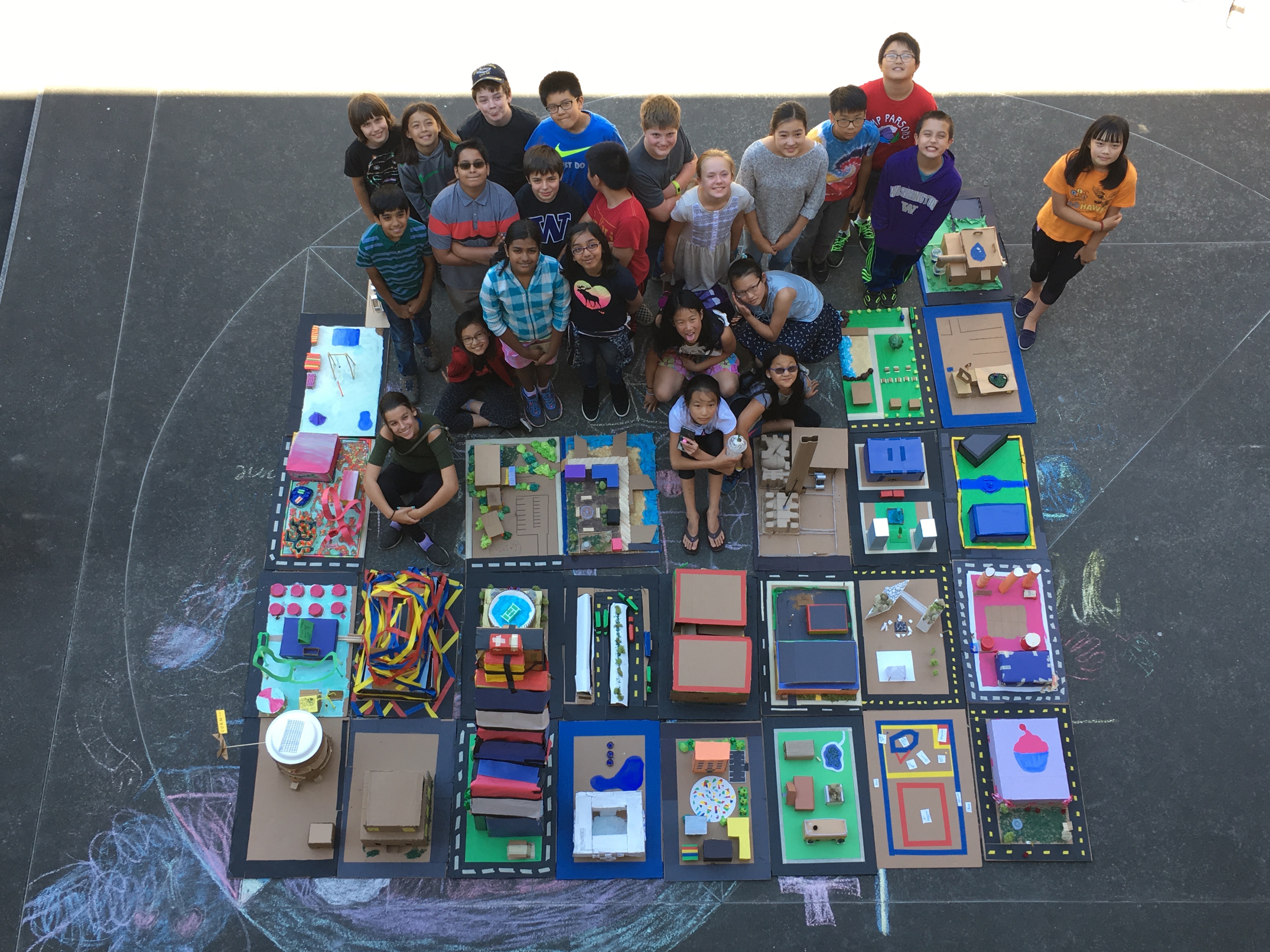
The Final Project As a class, students were asked to plan, design, and build a city – all in less than three weeks! We started with a simple 21-block site based roughly on Seattle’s South Lake Union neighborhood. The size of the site (21 blocks) was chosen based on the size of the class (21 students). After a few impassioned and thoughtful full-group discussions—along with a few some teacher-imposed restrictions—the class agreed upon their city’s final land use map. Each of the 21 blocks was numbered and assigned a land use according to our simplified zoning code, which included: Residential (yellow), Commercial (yellow), Parks/Open Space (green), and Institutional/Industrial/Governmental (blue). We then gave students some time to think about the types of buildings they would like to model on their individual city blocks. Once everyone had an idea of the type of building they wanted to build, we asked students to split into groups based on their proposed building’s land use type. For example, if Student A was interested in building a library (Institutional/Industrial/Governmental land use designation), then they would get into a group with other students proposing Institutional/Industrial/Governmental buildings. Each land use group was then asked to divide up their assigned blocks amongst the group members. After some negotiation within and across groups, students signed up for their individual blocks, each with their own unique zoning restrictions. For instance, the Institutional/Industrial/Governmental group, according to the previously agreed-upon land use map, “controlled” Blocks 3, 8, and 11. In the end, Student A ended up negotiating for Block 11 as the site for their proposed library. Before students could start building their models, the class also agreed upon a street hierarchy and transportation network, which would determine how much of each block would be dedicated public right of way. Finally, students worked for two full days to build their three-dimensional models using a variety of craft supplies and recycled materials. Each student even modeled the topography of their block, using layers of cardboard cut into contours modeled in SketchUp. On the final day of camp, parents and family members were invited to visit the classroom to see students present their individual models, as well as the work completed by the entire class. Supporting materials include:
For more information, contact: Stephanie Velasco, recent graduate from the Master of Urban Planning program at the University of Washington. Image: Students and their final projects, Summer of 2017, courtesy of Stephanie Velasco. Related Content: Youth, Planners, Teachers, Comprehensive Planning, Social Studies, Language Arts, The Arts |
Upcoming Events
Wed Sep 23, 2026MRSC Webinar - Implementing and Monitoring Local Climate Plans Webinar Category: APA WA Events |
View Full Calendar
The Washington Planner
APA Washington's Monthly NewsletterRead the latest issue>>
Submit an article>>
Sponsors